Hillside view of the former town of Eola, date unknown. WHC 2004.10.360
Have you ever time-traveled on your daily commute? I’ll admit to it. It’s one of my favorite pastimes as my jeep heads west for home along Highway 22. I particularly love the short stretch of road formerly known as the town of Cincinnati, later renamed Eola. The town boundary begins at the bluff where the Rock-N-Rogers Eola Inn restaurant sits across from Doaks Ferry road. The restaurant sits on a portion of the original donation land claim of pioneer William Duran, the first to sketch out the layout of the town and advertise lots for sale in the September 12, 1850 edition of the Oregon Spectator.
Just past the restaurant, located on the north side of the road, is J & J Tree & Stump Removal where you can usually spot one or two chainsaw sculptures, depending on the time of year. Whenever I spot them I chuckle thinking back to a 1907 Oregonian article about Eola. The article described local resident Breeze Gibson as a pioneer bachelor farmer “who has gained something more than local fame by reason of his seeing art in nature (he having cut all sorts of animals out of the sides of stumps and trees).” Then my mind wonders, could the current owner of the business be a descendant?
But I’m getting a little ahead of myself. The town was originally founded and named by Joshua “Sheep” Shaw whose family enjoyed the distinction of being the first immigrants to drive a flock of sheep over the Oregon Trail. He named the area Cincinnati after his former home in Ohio. It was not however, until William Duran arrived and settled the land claim adjacent to Shaw’s, that the town began to attract more people and businesses in the early 1850s.
The original town layout sloped generally south, not quite square with the compass, its forty-five numbered blocks and public square rising from the river margin where Shaw’s mills originally stood. In 1856 it was granted a charter of incorporation by the legislature and the name changed to Eola. There are differing accounts explaining the origin of the name change. Some attribute it to a local musician that was fond of playing the Aeolian harp. Another version of the story, credits Aeolus, Greek God of the winds. Whatever the reason, the name Eola stuck.
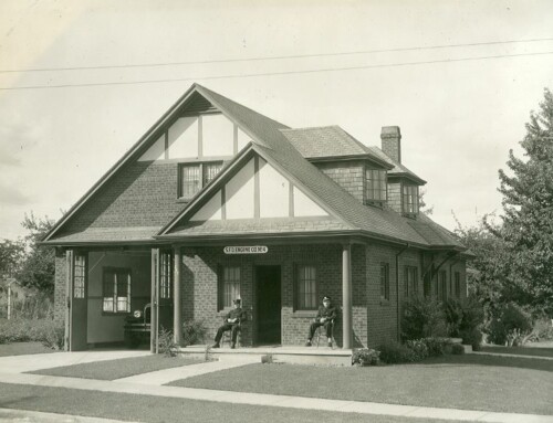
My mind continues to travel back through history when I spot the old school up on the hill, now a church. The structure was built in the 1930s as a WPA project and was actually the third school to be built in the town. The first dates to 1853, a one-room structure that boasted Miss Jane Scott as its first teacher, a woman who in later years under the name Abigail Scott Duniway would go on to achieve fame as a pioneer advocate of equal suffrage for women. Despite early bragging rights, the school developed a reputation for troublesome pupils. In the late 1860s, two of the Benjamin Hayden children took top prize in this category. Twelve-year-old Billy, rather mature and husky for his age, was a close match in size for the teacher, Mr. Ingalls. One day Billy put up a fight rather than submit to the corporal punishment his teacher planned. His sister Estelle watched with mild amusement and some amount of indifference, according to onlookers. But as Mr. Ingalls gained control of the situation and administered the beating, Estelle sprang into action, smashing her slate over the teacher’s head. Other pupils quickly joined the fight and soon enough, school and Mr. Ingalls were out for the day.
On the south side of the highway lies just as much history, though it takes more imagination since the old structures are gone. The original town docks and warehouses once stood where Rickreall Creek empties into the Willamette River, near present-day Salem Yacht and Boat Club. Then as now, the area was home to manufacturing businesses. The Pacific Coast Business Directory of 1867 lists a tannery, sawmill, blacksmith, wagon and furniture maker, saddlery and harness maker, and potters along with two hotels, lawyers and even a doctor.
By the mid-1870s Salem’s prominence as a regional trade center was being felt by many outlying communities, including Eola. River traffic began to give way to the expanding rail system. One by one Eola’s businesses closed or relocated. Then came the devastating flood of 1890 that destroyed all but one warehouse and changed the main channel of the Willamette leaving some property owners with land in the adjacent county of Marion. It was a death blow the city never quite recovered from.
This article was written by Kaylyn Mabey for the Statesman Journal where it was printed 15 April 2018. It is reproduced here with sources for reference purposes.
Sources:
- Oregon Spectator, 12 Sep 1850, p. 3, Historic Oregon Newspapers
- Historic Oregonian, 30 Jun 1907, p. 6, Newsbank
- Historically Speaking, Polk County Historical Society, Vol. IV, p. 4
- plat map available thru Polk County Assessor’s website
- Willamette Landings: Ghost Towns of the River, Howard McKinley Corning, p. 134
- Oregon Statesman, 4 April 1930,”Bits for Breakfast”, R.J. Hendricks
- Capital Journal, 25 May 1937,”Oldest Oregon School in Operation Doomed”, Ben Maxwell
- 1867 Pacific Coast Business Directory, Google Books
- Why Brown’s Island Was Moved from Polk to Marion County”, Ben Maxwell WHC X2014.018.0001