
Have an address in Salem, Oregon that dates to before 1904? Chances are you will have a difficult time finding it on today’s map. The City of Salem changed the address numbering system throughout the city in a city ordinance in 1904.
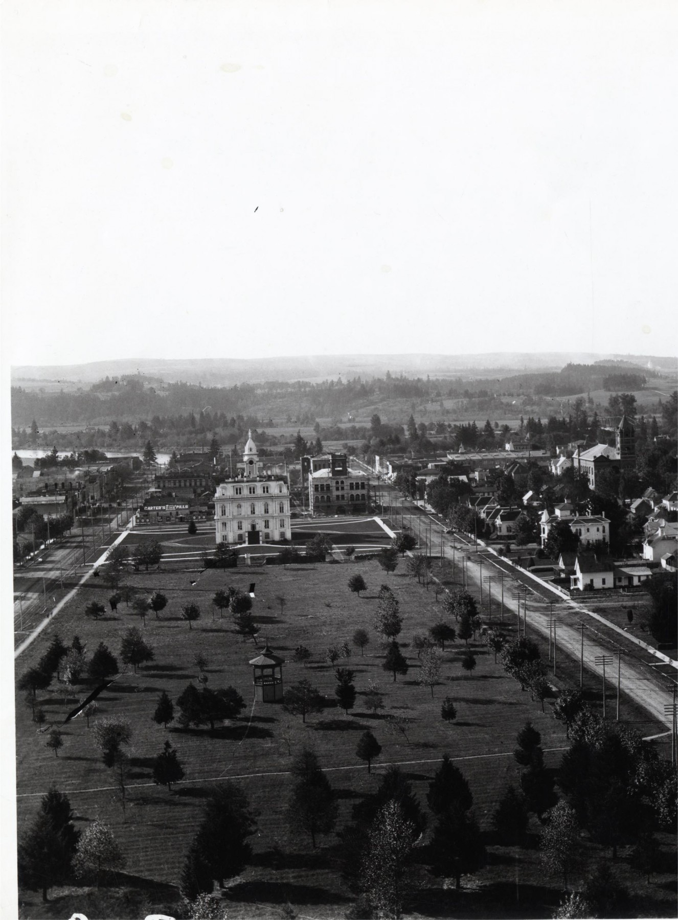
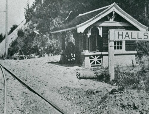
Photo Source: Willamette Heritage Center, Al Jones Collection, 2004.010.0646
House Numbering (Address) Ordinances
Ordinance 151, approved May 20, 1885, provided for numbering of houses in Salem [Oregon]; Ordinance 436, Approved October 10, 1904, revised the system. See examples below.
Prior to October 1904, Salem house numbers ran south to north, beginning at Leslie Street, allowing 40 numbers per block. Therefore, from Leslie to Oak, the odd numbers ran from one to thirty-nine on the west side of the street and the even numbers ran from two to forty on the east side of the street. this pattern of 40 numbers per block continued to the city limits. Also until 1904, the numbers running west to east began at Water Street, and continued in groups of 40 per block, to the eastern city limits. As an example, the odd numbers ran from one to thirty-nine on the north side of the street between Water and Front. The even numbers ran from two to forty on the south side of the street.
Ordinance Number 436, approved October 10, 1904, provides for the present house numbering system. State Street became the north-south dividing line and each block contains 100 numbers. Beginning at State Street, the block between State and Ferry has odd numbers from 101 to 199 on the est side and even numbers 102 to 198 on the east side with the designation SOUTH. Beginning at State Street going north, the block between Sate and Court has odd numbers 101 to 199 on the west side and 102 to 198 on the east side, all designated NORTH. Court to Chemeketa is the 200 Block north, Chemeketa to Center is the 300 block north, etc. Similarly, since State to Ferry is the 100 block south, Ferry to Trade is the 200 block south, Trade to Mill is the 300 block south, etc.
Numbering eastward, Water Street* remains the starting point and each block was renumbered to have 100 numbers available. So Water to Front is the 100 block, Front to Commercial the 200 block, Commercial to Liberty the 300 block, etc. odd numbers on the north side, even numbers on the south side.
*It will do the reader well to note that Water Street used to extend much further south that it does today — Most of Riverfront Park was industrial land with a need for addresses. You can see the layout of the streets at the time of the ordinance adoption in the 1895 Sanborn Fire Insurance Maps (available online and for free through the Library of Congress Website).
Numbering
Ordinance 436, Sec. 2. Houses on east side of the street running north and south shall be numbered as follows: Beginning at extreme south end of each street, number even from:
| STREET | PRE 1904 | POST 1904 |
| Leslie to Oak | 2-40 | 600 S. |
| Oak to Bellevue | 42-80 | 500 S. |
| Bellevue to Mill | 82-120 | 400 S. |
| Mill to Trade | 122-160 | 300 S. |
| Trade to Ferry | 162-200 | 200 S. |
| Ferry to State | 202-240 | 100 S. |
| State to Court | 242-280 | 100 N. |
| Court to Chemeketa | 282-320 | 200 N. |
| Chemeketa to Center | 322-360 | 300 N. |
| Center to Marion | 362-400 | 400 N. |
| Marion to Union | 402-440 | 500 N. |
| Union to Division | 442-480 | 600 N. |
| Division to Fir | 482-520 | 700 N. |
| Fir to North | 522-560 | 800 N. |
Houses on south side of streets running east and west shall be numbered:
| STREET | PRE 1904 | POST 1904 |
| Water to Front | 2-40 | 100 |
| Front to Commercial | 42-80 | 200 |
| Commercial to Liberty | 82-120 | 300 |
| Liberty to High | 122-160 | 400 |
| High to Church | 162-200 | 500 |
| Church to Cottage | 202-240 | 600 |
| Cottage to Winter | 242-280 | 700 |
This article originally appeared in the Summer 1998 edition of Historic Marion – a publication of the Willamette Heritage Center’s predecessor organization – the Marion County Historical Society. Because WHC staff references this article nearly daily in working with research requests, it has been reproduced here for reference.
When did NE/SE designations get added to Salem Addresses?
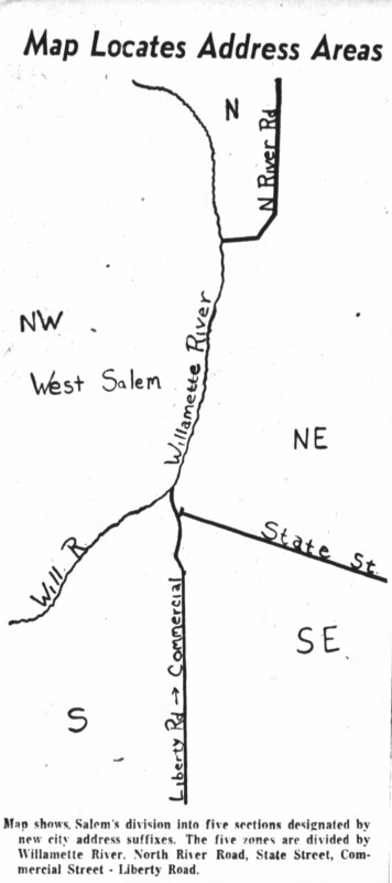
MAP of newly implemented address suffix zones. Oregon Statesman 13 October 1957 pg 30
The suffixes were added to Salem addresses in 1957, corresponding to specific zones in the city, rather than based on street direction. The new system, in the words of then City Engineer J.H. Davis, was implemented to “make addresses more consistent with the city’s geography and allow easier identification of addresses. The change was adopted by the city council in Spring 1957, and became effective July 1, 1957. However, it was a slow process and street signs only started to be physically changed in October 1957.
Zones Adopted
| Zone | Boundaries | Example |
| 1 – Northeast (NE) | Area north of State Street and east of North River Road. Note both sides of N. River Road north of the sewage treatment plant will be numbered with NE suffix | 4055 River Rd NE |
| 2 – Southeast (SE) | Area south of Sate Street and east of commercial street out Liberty Road. Both sides of Commercial street and Liberty road south of Mission street will be numbered with SE suffix | 1635 Commercial St SE |
| 3 – Northwest (NW) | All of West Salem and the area on the west side of the Willamette River | |
| 4 – North | The triangle north of the sewage disposal plant and west of North River Road to the Willamette River | |
| 5 – South | area between Mission Street and Rural Avenue West of South Commercial Street and east of the Willamette River. Alternative described as: The triangle north of the sewage disposal plant and west of North River Road to the Willamette River | |
| 6 – Southwest (SW) | applies only to a small stretch between the Willamette River and the NW area | |
| Note | Both sides of State Street will be known only as State Street | 2135 State St. |
In addition to the suffixes, about 289 addresses in the south district (area between Mission and Rural Street west of South Commercial Street and east of the Willamette River) had their numbers changed. This included houses on Mission Street (7), Kearny Street (10), Bush Street (17), Owens Street (26), Miller Street (39), Wilson Street (28), Myers Street (19), Lefelle (23), Lincoln Street (20), Superior (26), Luther (19) and Rural (31). Examples given in the press: “The present 231 Mission Street will become 155 Mission St. S; 236 East Bush Street will become 160 Bush Street S; and 255 East Superior Street will become 145 Superior St S.”
References:
“New Address System Set for Monday.” Capital journal 28 Jun 1957 pg 9
Stevens, Robert L. “Work to Start This Week on New City Street Signs.” Oregon Statesman 13 Oct 1957 pg 30.
“Suffixes are now with us.” Oregon Statesman 14 Oct 1957 pg 4
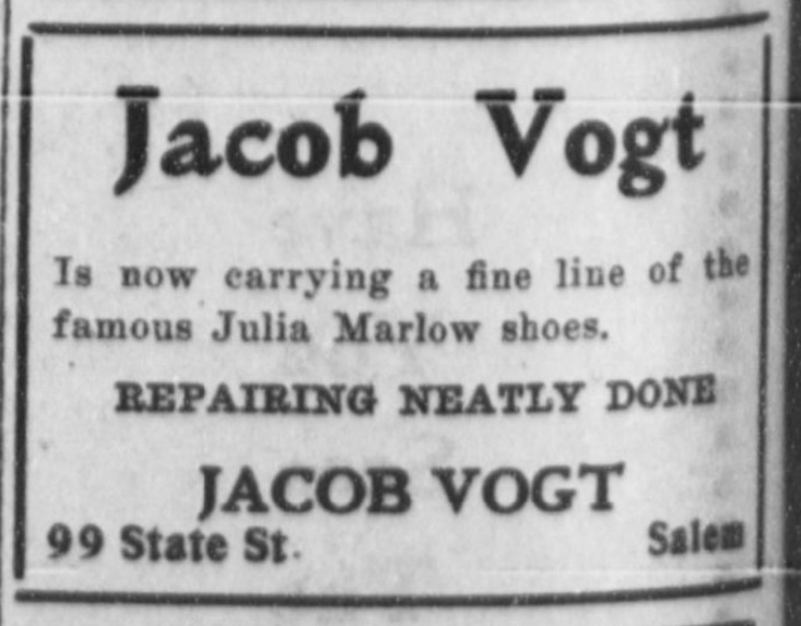
Article. Published Capital Journal 24 October 1904. Note the 99 State Street address. Although the ordinance was approved October 10, 1904, it took some time to take effect. Using the chart above, we can also locate this business to be on the north side of (odd number) of the street and between Commercial and Liberty.
I am seeing an address of 3 Route 4 in Salem, Oregon – I can not find what street name Route 4 became in Salem. Thanks!
Rural routes can be super challenging to reverse engineer, because they weren’t a single street, they were on a postal route, outside city limits, that often corresponded to a very large area. The museum has some rural route maps in the collections that can be used for some cross-referencing, but it will depend on the date of the address you have found. Do you have a date of the 3 Route 4 address?
Other ways to help find clues…
CENSUS RECORDS: If you can find the individual on the census records, there are precinct maps that can help narrow down location in rural areas.
METSKERS MAPS: The WHC has maps from the 1920s, 1940s and 1970s that show landownership in Marion County, listed by owner’s name.
PROPERTY RECORDS SEARCH: The tedious, but most accurate way to find the property (assuming the person owned it, not rented it) would be through searching deeds. We have a cheesy, but effective tutorial video here on how to go about that in Marion County: https://www.willametteheritage.org/research/couch-historian-webisodes/. Episode 6.
NEWSPAPER ACCOUNTS: Sometimes you get lucky with clues as to location (by the grange hall, etc.). You can check out how to access free newspaper databases with link above Episode 2.