
Salem Streets: Curious origins of width and angle
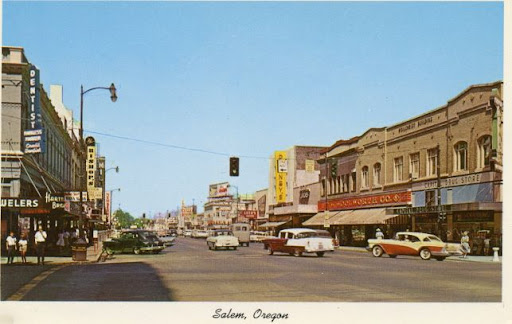
Anderson Sundry Co., Portland Oregon Publishers, Color view of Liberty Street in downtown Salem. There is a street light hanging in the middle of the one way street. Signs say: Dentist, Jewelers, Hartman Bros., Bishop’s, Millers, Newberrys, Leeds Store, Penney’s, Woolworth Co. and Capitol Drug Store., WHC Collections 2011.006.0358
There is more than one story about how Salem’s downtown streets go as wide as the are – – 99 feet.
One reason given is that the original survey was done with a chain 66 feet long, with links 7.92 inches long. It was considered too narrow to have streets only one chain wide, so they used a chain and one half, or 99 feet, according to the late Salem City Engineer, Harold Davis.
Another tradition says that 66 feet would have been inadequate for oxen teams and two chains wide would have been too much.
Still another theory was that the wider streets would discourage the spread of fire from one side to the other.
Salem was surveyed again in June of 1861 by Jerome B. Greer and Walter Forward. It set 19 survey control points (monuments) from which exact locations could be measured legally. Most of the monuments are still used.
The point from which all elevations were measured was a brick projecting from the Marion Hotel’s northwest corner, 2.78 feet above the sidewalk and 48 feet from mean-low water level of the Willamette River, Davis explained.
And why do Salem streets turn at an angle as they leave the downtown, going north, east, or south? It is because the original plats were laid out with magnetic north as the needle pointed 150 years ago. Later additions were measured by true north – – which is about 19 degrees different.
Written by Al Jones, compiled by Cynthia Harvey and Monica Mersinger
Bibliography:
Marion County HISTORY, Volume XV, Page 124 (Previously published Winter 1996, Vol. 34, No. 4)
This article originally appeared on the original Salem Online History site and has not been updated since 2006.
Leave A Comment